Written By | Torch Media Africa
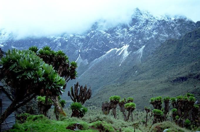
At some point on the way up, the world stops behaving. The banana groves of the Bakonzo farmers fall away, and the trail climbs into a forest so drenched in moss that every trunk looks upholstered.
TOURISM
The Rainmaker Range
The Rwenzori Mountains are not a volcano and not a lone peak. They are a block of ancient rock shoved skyward along the Albertine Rift, straddling the Uganda–Democratic Republic of Congo border. The Ugandan side is protected as Rwenzori Mountains National Park, roughly 1,000 square kilometres of forest, moorland and glacier in the country's west, with the town of Kasese as its gateway. The park was established in 1991, inscribed as a UNESCO World Heritage Site in 1994 and recognised as a Ramsar wetland of international importance in 2008.
The Bakonzo people know these peaks as the home of Kitasamba, the rainmaker god, and the name is earned: the range wrings enormous quantities of rain from the clouds, which is why so much of it is hidden. The Greek geographer Ptolemy is often credited with recording a snow-capped 'Mountains of the Moon' as a source of the Nile, and the Rwenzori remain the leading candidate for that legend. Its highest massif, Mount Stanley (Ngaliema), carries several peaks above 5,000 metres, crowned by Margherita Peak at 5,109 metres, the third-highest summit in Africa.
Five Worlds in One Climb
What makes the Rwenzori extraordinary is how much of the planet it compresses into a single ascent. Trekkers pass through five distinct belts: farmed lowlands of coffee, vanilla and banana; montane forest at around 2,500 metres; a zone of giant bamboo near 3,000 metres; heath and moorland toward 4,000 metres; and finally the afro-alpine realm, where the giant lobelias and groundsels live, and where equatorial glaciers and permanent snowcaps still cling on, even as they shrink.
The wildlife rewards patience rather than luck. The forests shelter the Rwenzori red duiker, Rwenzori colobus and blue monkeys, and the Rwenzori three-horned chameleon, while birders can tick off 17 of the 24 bird species endemic to the Albertine Rift, among them turacos, handsome francolins, sunbirds and several eagles. This is not a big-cat-and-elephant park. It is a place of small, strange, precisely adapted things.
Choosing Your Trail
Serious climbers head for Margherita Peak by one of two main routes. The Central Circuit, starting from the park headquarters at Nyakalengija, is generally run over seven to nine days, looping through the Bujuku and Mubuku valleys past a chain of high lakes. The Kilembe Trail, which begins at Kilembe on the far side, usually takes eight to ten days to reach the same summit country. Neither is casual: the ground is boggy, the air is thin and the weather changes by the hour.
Not everyone wants a fortnight in the mud. Shorter options include day walks and one-to-three-night hikes on the lower slopes, including forest routes such as the Mahoma Trail through bamboo, and the Bujuku Valley for panoramic views without a full expedition. Community-run walks around Nyakalengija, where Bakonzo guides share stories of the mountain and its spirits, add a cultural layer that many visitors remember longest.
Practical Information for Visitors
Access is via Kasese, roughly a full day's drive from Kampala, with the park headquarters at Nyakalengija and Kilembe Base Camp as the two main starting points. Accommodation runs from campsites and simple huts at the trailheads to lodges and guesthouses in and around Kasese. All treks require a licensed guide and porters, so most visitors book through a local operator, whose package fee covers meals, equipment and crew.
Operator guides list park entrance fees of US$35 per day for foreign non-residents, US$25 for foreign residents, UGX 150,000 for East African citizens and US$5 for children, with additional peaks costing around US$100 each and unplanned extra days about US$150. A seven-day Central Circuit therefore includes roughly US$245 in entrance fees alone before any operator costs. Fees change, so confirm current rates with the Uganda Wildlife Authority or your operator before you travel.
The driest and clearest trekking windows are December to February and June to August, although the range receives more than three metres of rain a year and no month is guaranteed dry. Waterproofs, gaiters, warm layers and a healthy respect for altitude are non-negotiable. Allow time to acclimatise, and treat the mountain's weather as the real itinerary.
This Week in Ugandan Tourism
27 September — Uganda marked World Tourism Day in Mbale under the theme 'Digital Agenda and Artificial Intelligence to Redesign Tourism.' The Ministry of Tourism, Wildlife and Antiquities used the occasion to promote AI in destination marketing and to broaden the pitch beyond wildlife to coffee, culture and adventure in eastern Uganda, including Mount Elgon and Sipi Falls. A wildlife education facility was also established in Mbale.
28–30 September — The 'Explore Eastern Uganda' domestic tourism campaign runs through the end of this month's Tourism Month, alongside a free-access initiative at selected national parks meant to encourage Ugandans to travel at home.
Announced 27 September — The ministry reported 739,815 international visitors in January–June 2026, up 3.7 percent year on year, with tourism receipts of Shs2.3 trillion, up 25.6 percent, and average stays lengthening from 7.4 to 8.3 nights.
16–17 September — A Ugandan delegation of 11 operators, double last year's number, courted French and European buyers at the IFTM Top Resa fair in Paris, pitching gorilla permits, wildlife packages, Rwenzori trekking and itineraries tied to Uganda's co-hosting of the 2027 Africa Cup of Nations. France sent 7,439 visitors in 2025, more than double 2024.
19 September — Reporting on Uganda Wildlife Authority figures put gorilla tourism revenue at Shs110 billion in 2025/26, up from Shs93 billion the year before, as the mountain gorilla population continues to grow. A census launched in May 2025 is still awaiting DNA analysis.
The Last Word
For all Uganda's fame for gorillas and savannah, the Rwenzori remain the country's quiet marvel: a place where you can stand in the tropics and watch your breath freeze. It is slow, wet and hard-won, and that is exactly the point. Come for the summit if you must, but stay for the forest, the lobelias and the moment the clouds finally part.